| Next Chapter | Previous Chapter | |
| Chapter 47: CLANRO, Inc. II, The Ideals | Contents | Chapter 45: My Friend Jack Shock |
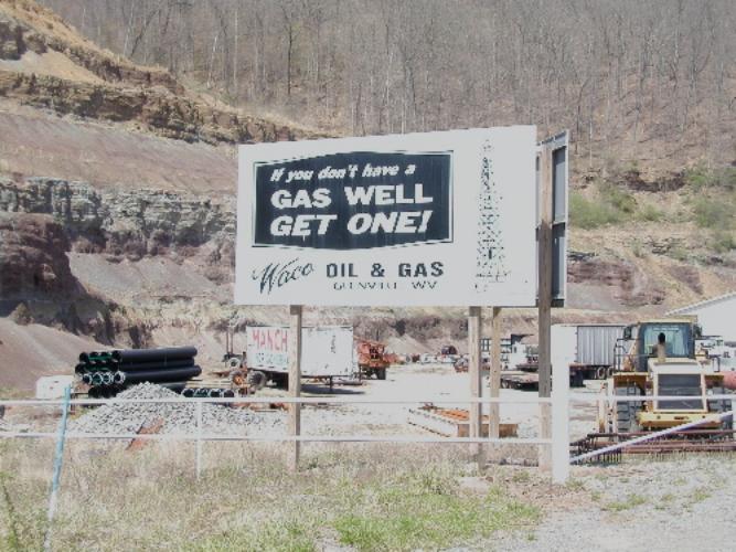
When it became public knowledge that Consolidated planned to build the Lost Creek Storage Field many people thought it was the end of the world, their world, at least. Consolidated was a damnable outfit at best. They bought any law they wanted and pushed every advantage they gained to the limit. They had such a strong place economically they could provide their employees with a good living for
(Illustration 46-1)
An attitude
minimal effort on the employee’s part. They maintained the equivalent of a dossier on everyone by grilling their employees. One landman, Joe Garrett, in the course of a friendly conversation on company business asked me about things in my life from twenty years before that I had entirely forgotten, and this was fairly typical. Through their employees they knew everything about everyone and could bring it to bear on demand. The corporation donated to charity, colleges and other good works, garnering advantages from that. They were well thought of in business and political circles but not by people who had to deal with them.
For readers who do not know what a gas storage field is, let me interrupt a moment to explain. The demand for natural gas is greatest in winter, and production is more or less uniform year around. The objective of the storage field is to receive gas from “the Southwest,” Louisiana and Texas fields, in relatively small diameter pipe at a uniform rate, and deliver it to the cities in the Northeast in the winter through larger diameter pipe. Containment of the gas is tricky engineering, since the underground formations can not be directly examined but must be inferred from well logs and conductivity and sound wave information, along with other indirect means.
Gas comes from the pores of some sandstone formations. Likewise, it can be pumped back into those pores, stored and removed later. This is the function of a storage field. It is much cheaper and safer to store gas in these formations than in tanks. Natural gas contains compounds known as hydrocarbons. These are identified by the number of carbon atoms in the compound: C1 (read “see – one”) means to have one carbon, C2, means having two carbons, and so on. C1 to C3 are gas at atmospheric pressure, the higher members of the series are liquids. Natural gas used in commerce consists mainly of C1. Higher members of the series are removed for other uses. Higher members also have higher heating value. When C1 is pumped back under ground where gas has previously been removed more of the higher members of the series evaporate into it, much as water evaporates into dry air, so gas storage also removes additional petroleum products from the storage field, giving added value, because it is easily removed.
We found out later that the original storage, the Fink Storage Field, in Lewis County, had leaked out into the Lost Creek area through a spot on Kicheloe Creek. The engineers had failed to recognize an outlet. Storage was in the Gantz Sand (sandstone rock formation). This was known to be an ancient river, and the sandstone was a consolidation of sand beds deposited by the river several hundred millions of years ago. Gas eventually leaked out of the Lost Creek Field into an area which is now the Bridgeport Storage
(Illustration 46-2)
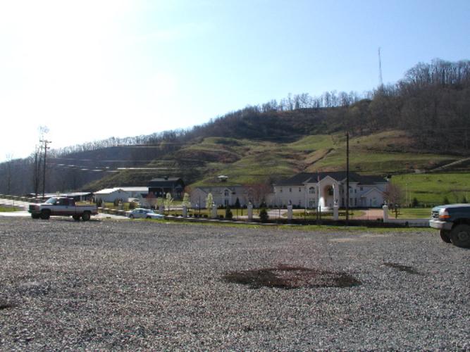
A little bit o’ Texas in West Virginia, left side view. Notice horse barns on the left and horses on the hill.
Field. I don’t know if it has stopped moving yet.
Gas may leak up and down through old wells, which were often improperly plugged (refilled and sealed when the extraction process is finished). One leak when the field was highly pressured led into the aquifers at McWhorter. There was a burning flare fifty feet high at Jim Hoover’s new house, about 100 yards from the I-79 overpass at McWhorter, which caused considerable embarrassment to Consolidated. Jack Shock, who lived a quarter of a mile away, had so much gas in his water he threatened to put a separator on his water well and use the gas from his well rather than gas supplied by the utility.
(Illustration 46-3)
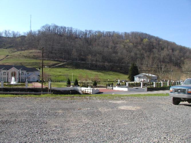
A little bit o’ Texas in West Virginia, right side view. Two fountains and a full time lawn and groundsman.
Consolidated bought Hoover’s house, and had to control the pressure in that part of the storage field to put out the flare.
Consolidated spent tens of thousands of dollars on my mother’s farm, diging around looking for a well that had not been properly plugged, all trace of which had been obliterated by strip mining. They never did find it, and after they left we had a shallow pond in that spot until the coal was stripped again. My mother said there were fourteen oil wells there when she came to the Lost Creek farm in 1932, and old maps show many others in the area around our farm. There are many, many old wells, a lot of them never reported or put on maps.
Aside One of the infuriating things about dealing with the gas company is that they know what is down there, under the surface, and the landowner and the mineral owner don’t. A few years after we got the farm on Jesse Run, when I was relatively young and innocent, I came up over the little hill just west of our house and there was a geophysical truck with a thumper and geophones. The thumper pounds a heavy weight on the ground to make sound waves in the earth, and the geophones pick up the reflections as they come back from the different formations below. This tells distance down to the reflective formations, and can be integrated over some distance from one place the truck stops to another to tell the shape and thickness of these formations.
I recognized what was going on because I have an interest in geology and knew about the device. I complained to the guy about it, and he told me I could not get the information they were taking. He also told me that the State of West Virginia had given the company permission to use the road to get the information, I couldn’t stop them. I was fool enough to take these statements then. I learned later that the State doesn’t own the property under the road, I do. All the State has is a right of way for the road. Not for telephone or electric lines, not for TV cables and certainly not to extract information. Only a road. (I found out later this right of way has been extended to railroad tracks, water and sewage lines, since the bill said “transportation” rather than “roads,” the original intent.) The State couldn’t have given permission to extract information. It was a more or less typical oil and gas company lie.
The drilling companies must submit well logs (a list of formations they run into and depth when they drill a well), but nothing is ever verified, and minerals other than oil and gas are largely ignored in the data submitted to the state. We would be able to trace a coal seam from proper logs, but you can’t with the record. They know what is down there, but you can’t find out from the public record.
| Next Chapter | Previous Chapter | |
| Chapter 47: CLANRO, Inc. II, The Ideals | Contents | Chapter 45: My Friend Jack Shock |
Copyright © 1998, 2006, 2008, 2011 S. Tom Bond (stombond at hughes.net)